Abstract
This study investigates the impacts of climate change on glacial lake dynamics and associated Glacial Lake Outburst Flood (GLOF) risks in the Nepal Himalaya from 2005 to 2024, employing a comprehensive geospatial and statistical analysis. Utilizing high-resolution satellite imagery and climatological data, we documented a dramatic proliferation of glacial lakes, with the total number increasing from 1,926 to 2,631—a net gain of 705 lakes—across major Himalayan ranges. This rapid formation is directly correlated with significant regional warming, with a mean annual temperature increase of 0.06°C, and erratic precipitation patterns. The research identifies and classifies these expanding lakes, highlighting their growing potential for GLOFs, which pose a severe transboundary threat to downstream communities and infrastructure. Furthermore, the analysis delineates key anthropogenic drivers—including deforestation, escalating wildfires, industrial emissions, and agricultural practices—that are exacerbating the region's climate vulnerability. The findings underscore the critical need for continuous monitoring of glaciers and glacial lakes and the urgent implementation of adaptive mitigation strategies to address the escalating climate-induced hazards in this ecologically fragile and topographically complex region.
Keywords
Climate Change, Glacier Lakes, Nepal Himalaya, GIS and Satellite Based Images, Temperature Rainfall, Humidity
1. Introduction
The pervasive and accelerating impacts of climate change have precipitated profound alterations in global ecosystems, with mountainous regions such as the Nepal Himalaya experiencing particularly deleterious consequences
| [7] | Karki, Rahul & Gurung, Dr. Anup. (2012). An Overview of Climate Change And Its Impact on Agriculture: a Review From Least Developing Country, Nepal. Int. J. Ecosys. 2. 19-24. https://doi.org/10.5923/j.ije.20120202.03 |
[7]
. The inexorable rise in greenhouse gas concentrations, driven by anthropogenic activities and industrialization, has engendered a discernible escalation in global surface temperatures, with an increase of 0.3 to 0.6°C observed over the past century. This phenomenon has manifested acutely in the Himalayan region, where temperatures are ascending at a rate surpassing the global average, exacerbating glacial retreat and the proliferation of glacial lakes
| [6] | Raut, A. K. (2004). Climate change: Nepalese perspective. Earthtimes Maplecroft (2010). “Big economies of the future - Bangladesh, India, Philippines, Vietnam and Pakistan - m o st at risk from climate change.” Bath, U. K., Oct. 21, 2010 |
[6]
. The resultant proliferation of these lakes augments the propensity for glacial lake outburst floods (GLOFs), which have already inflicted catastrophic transboundary repercussions, including significant fatalities and infrastructural devastation downstream
.
Nepal, ranked among the most climate-vulnerable nations globally, epitomizes the confluence of climatic volatility and topographic susceptibility. The region’s intricate geomorphology, spanning from the Indo-Gangetic Plain to the Tibetan-Tethys Himalaya
| [4] | Gansser, A., 1964. In: Geology of the Himalayas. Wiley Interscience, London. 289 p. |
[4]
, renders it acutely sensitive to climatic perturbations. The Himalayan glaciers, which constitute a critical reservoir of freshwater, are receding at an alarming rate, with projections indicating a potential reduction of up to 40% in area and 50% in volume per 1°C temperature increase. This retreat has precipitated the formation of over 1,466 glacial lakes, 21 of which are deemed perilously unstable. The concomitant risks of GLOFs, landslides, and altered hydrological regimes underscore the exigency for comprehensive monitoring and mitigation strategies.
Furthermore, the region’s climatic heterogeneity, encompassing tropical to polar zones, exacerbates its vulnerability to erratic precipitation patterns, heightened humidity fluctuations, and the encroachment of tropical diseases into elevated altitudes
| [3] | Dhimal, M., O’Hara, R. B., Karki, R., Thakur, G. D., Kuch, U., & Ahrens, B. (2014). Spatio–temporal distribution of Malaria and its association with climatic factors andvector–control interventions in two high–risk districts of Nepal. Malaria Journal, 13(1), 457. https://doi.org/10.1186/1475-2875-13-457 |
[3]
. The synergistic effects of deforestation, rampant industrialization, and unsustainable agricultural practices have further compounded these challenges, amplified carbon emissions and accelerating glacial melt
| [12] | Parajuli, Ashok & Chand, Deepak & Rayamajhi, Bishal & Khanal, Rajendra & Baral, Sony & Malla, Yam & Paudel, Shambhu. (2015). Spatial and temporal distribution of forest fires in Nepal. |
[12]
. During the peak flow period in July, higher temperatures, a larger area of exposed ice, and a smaller snow cover combined to accelerate glacial melting. This, in turn, led to increased discharge in the regions
| [1] | Singh, P., Haritashya, U. K., Kumar, N., Singh, Y., 2006. Hydrological characTearistics of the Gangotri Glacier, central Himalayas, India. J. Hydrol. 327 (3–4), 55–67. |
[1]
.
This study elucidates the temporal and spatial dynamics of glacial lake formation in the Nepal Himalaya, leveraging GIS and satellite imagery to delineate the alarming proliferation of these water bodies between 2005 and 2024. By analyzing trends in temperature, precipitation, and humidity, we underscore the region’s escalating susceptibility to climate-induced hazards. The findings underscore the imperative for robust adaptive measures to mitigate the multifaceted threats posed by climate change, ensuring the resilience of both ecosystems and human communities in this ecologically fragile and topographically complex region.
2. Study Area
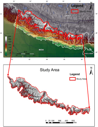
The study area encompasses the diverse and topographically complex regions of the Nepal Himalaya (
Figure 1), spanning from the eastern to the far western sectors of the country. Geographically, it is delineated by coordinates 30°25'10.92"N, 81°24'29.39"E to 27°50'36.39"N, 88°10'33.48"E, as provided by the Department of Survey, Government of Nepal. This expansive territory is situated within the Higher Himalaya ranges, characterized by high-grade metamorphic rocks such as gneiss, schist, and quartzite, as well as igneous formations like granite and pegmatite
| [4] | Gansser, A., 1964. In: Geology of the Himalayas. Wiley Interscience, London. 289 p. |
[4]
. The region's geomorphology is further stratified into distinct divisions, including the Indo-Gangetic Plain, Sub-Himalaya (Siwalik), Lesser Himalaya, Higher Himalaya, and Tibetan-Tethys Himalaya, each demarcated by significant lithological variations and thrust systems.
The study area's inaccessibility is pronounced, with certain sections devoid of roads or foot trails, while others are minimally serviced by local bus routes or narrow footpaths. Despite these logistical challenges, the research leverages advanced geospatial technologies, including GIS and satellite imagery, to analyze glacial lakes and climatic parameters across seven distinct Himalayan ranges: Dhaulagiri, Langtang, Solukhumbu, Machhapuchhre, Annapurna, Shey Phoksundo, and Mugu-Shypal Himal
| [11] | Glacial Lakes and Glacial Lake Outburst Floods in Nepal. Kathmandu: ICIMOD. http://www.icimod.org/publications |
| [20] | Bajracharya SR, Maharjan SB, Shrestha F, Bajracharya OR, Baidya S (2014) Glacier status in Nepal and decadal change from 1980 to 2010 based on Landsat data. International Centre for Integrated Mountain Development.
https://lib.icimod.org/record/29591 Last accessed 2023-10-05 |
[11, 20]
. These ranges exhibit pronounced susceptibility to climate change, evidenced by accelerated glacial retreat and the proliferation of glacial lakes, which pose significant risks of glacial lake outburst floods (GLOFs)
| [9] | Mool, P. & Bajracharya, Samjwal & S. P. Sakya, K. & Baidya, A.. (2002). Inventory of glaciers, glacial lakes and glacial lake outburst floods monitoring and early warning systems in theHindu-KushHimalayan region, Nepal.. International Center for Integrated Mountain Development (ICIMOD) tech. |
| [10] | lves, J. D., Shrestha, R. B. and Mool, P. K. (2010) Formation of Glacial Lakes in the Hindu Kush-Himalayas and GLOF Risk Assessment. International Centre for Integrated Mountain Development, Kathmandu.56pp. |
[9, 10]
.
The climatic heterogeneity of the study area is equally striking, encompassing tropical, subtropical, temperate, subalpine, alpine, and polar zones, each with unique temperature and precipitation regimes
| [15] | Shrestha, R. L., & Shrestha, S. (2015). "Climatic Zones of Nepal." Nepal Journal of Environmental Science |
[15]
. This variability exacerbates the region's vulnerability to climatic perturbations, such as rising temperatures and erratic monsoonal patterns, which have precipitated glacial melting and altered hydrological dynamics
. The study's focus on these ecologically fragile and climatically volatile areas underscores the imperative for meticulous monitoring and adaptive strategies to mitigate the escalating impacts of climate change
| [16] | Hu J, Yao X, Duan H, Zhang Y, Wang Y et al (2022) Temporal and spatial changes and GLOF susceptibility assessment of glacial lakes in Nepal from 2000 to 2020. Remote Sens 14: 5034. https://doi.org/10.3390/rs14195034 |
[16]
.
Figure 1. Study area map.
3. Geomorphic Division of Nepal Himalaya
The geomorphic division of the Nepal Himalaya, reflects a complex and stratified topography shaped by tectonic forces and climatic influences. The region is systematically categorized into distinct geomorphic zones, each characterized by unique lithological compositions and elevational gradients, which collectively underscore the dynamic interplay between geological processes and environmental factors
| [4] | Gansser, A., 1964. In: Geology of the Himalayas. Wiley Interscience, London. 289 p. |
[4]
.
Commencing from the southern periphery, the Indo-Gangetic Plain constitutes a low-lying alluvial expanse, juxtaposed against the Siwalik Hills, a fragile tectonic belt prone to slope instability and erosion. Progressing northward, the Mahabharat Range emerges as a formidable orographic barrier, precipitating pronounced monsoonal precipitation on its windward slopes
| [5] | Hagen, T., 1969. Report on the geological Survey of Nepal. Preliminary reconnaissance: Denkschriften der Schweizerischen Naturforchenden Gesellschaft, Memoires de la Societte Helvetique des Sciences naturees, Zurich, v. 86, pp. 185 |
[5]
. The Midlands, or Lesser Himalaya, exhibit temperate climatic conditions and moderate relief, while the High Himalaya dominates the landscape with its glaciated peaks and precipitous terrain, harboring the planet’s highest summits, including Mount Everest
. The Trans-Himalaya, extending into the Tibetan Plateau, represents an arid, high-elevation domain marked by subdued topography and sparse vegetation, culminating at the Indo-Tsangpo Suture Zone—a tectonic demarcation between the Indian and Eurasian plates
| [4] | Gansser, A., 1964. In: Geology of the Himalayas. Wiley Interscience, London. 289 p. |
[4]
). This hierarchical zonation not only elucidates the region’s geodiversity but also accentuates its susceptibility to climatic perturbations, particularly glacial retreat and lake formation
| [16] | Hu J, Yao X, Duan H, Zhang Y, Wang Y et al (2022) Temporal and spatial changes and GLOF susceptibility assessment of glacial lakes in Nepal from 2000 to 2020. Remote Sens 14: 5034. https://doi.org/10.3390/rs14195034 |
[16]
.
Such geomorphic stratification is pivotal for comprehending the spatial distribution of climate-induced hazards, including glacial lake outburst floods (GLOFs) and landslides, which exhibit pronounced variability across these zones
| [10] | lves, J. D., Shrestha, R. B. and Mool, P. K. (2010) Formation of Glacial Lakes in the Hindu Kush-Himalayas and GLOF Risk Assessment. International Centre for Integrated Mountain Development, Kathmandu.56pp. |
[10]
. The intricate interplay of elevation, lithology, and climatic gradients underscores the imperative for targeted monitoring and adaptive strategies to mitigate escalating environmental vulnerabilities in this ecologically sensitive region.
4. Climatic Zone of Nepal
The climatic zones of Nepal exhibit a remarkable gradient, influenced by the country’s dramatic altitudinal variation, which spans from the low-lying Terai plains to the towering peaks of the Himalayas. This topographic diversity engenders distinct climatic regimes, each characterized by unique temperature, precipitation, and ecological patterns. The following delineation of Nepal’s climatic zones elucidates these variations and their implications for the region’s environmental and socio-economic systems.
4.1. Tropical Climate (Terai Region)
The southernmost Terai region, situated at altitudes between 60 and 300 meters, epitomizes a tropical climate. This zone is subjected to sweltering temperatures, often exceeding 40°C during the summer months (March to June), and receives copious monsoon rainfall between June and September
| [15] | Shrestha, R. L., & Shrestha, S. (2015). "Climatic Zones of Nepal." Nepal Journal of Environmental Science |
[15]
. The Terai’s fertile alluvial plains are agriculturally prolific, yet its low-lying topography renders it highly susceptible to flooding and waterborne diseases, such as malaria and dengue, which are exacerbated by climate change
| [3] | Dhimal, M., O’Hara, R. B., Karki, R., Thakur, G. D., Kuch, U., & Ahrens, B. (2014). Spatio–temporal distribution of Malaria and its association with climatic factors andvector–control interventions in two high–risk districts of Nepal. Malaria Journal, 13(1), 457. https://doi.org/10.1186/1475-2875-13-457 |
[3]
.
4.2. Subtropical Climate (Lower Hills)
Adjacent to the Terai, the subtropical lower hills (300–1,200 meters) experience milder temperatures, ranging from 25°C to 35°C in summer and 10°C to 20°C in winter. The region’s moderate monsoon rainfall sustains lush vegetation and terraced farming, though deforestation and erratic precipitation patterns pose escalating threats to its ecological stability
| [12] | Parajuli, Ashok & Chand, Deepak & Rayamajhi, Bishal & Khanal, Rajendra & Baral, Sony & Malla, Yam & Paudel, Shambhu. (2015). Spatial and temporal distribution of forest fires in Nepal. |
[12]
. The interplay of elevation and monsoon dynamics here creates a transitional zone that is increasingly vulnerable to climate-induced disruptions.
4.3. Temperate Climate (Mid Hills)
The mid hills (1,200–2,400 meters) are characterized by a temperate climate, with summer temperatures between 10°C and 20°C and winter temperatures frequently dipping below 10°C. This zone supports diverse agro-ecological systems, including orchards and seasonal crops, but rising temperatures and shifting precipitation regimes are altering traditional farming practices (Karki & Gurung, 2012). The mid hills’ climatic intermediacy underscores their role as a buffer between the lowland tropics and the alpine highlands.
4.4. Subalpine Climate (High Hills)
At elevations of 2,400–3,600 meters, the subalpine high hills endure cool summers (5°C–15°C) and frigid winters, with temperatures often plummeting below freezing. The region’s moderate monsoon rainfall and winter dryness foster hardy coniferous forests and alpine pastures, which are critical for local livelihoods
. However, the encroachment of warmer climates and glacial retreat are destabilizing these ecosystems, with cascading effects on water availability and biodiversity.
4.5. Alpine Climate (Himalayan Region)
The alpine zone (3,600–5,500 meters) is marked by extreme cold, with winter temperatures below -10°C and summer temperatures rarely surpassing 5°C. Precipitation here is scant, predominantly as snow, and the landscape is dominated by glaciers and barren rock
. This region’s climatic austerity belies its hydrological significance, as it serves as the primary reservoir for South Asia’s major river systems, now imperiled by accelerated glacial melt
| [2] | Immerzeel, W. W., Van Beek, L. P., Bierkens, M. F., 2010. Climate changewill affect the Asian water towers. Science 328 (5984), 1382–1385. |
[2]
.
4.6. Polar Climate (Highest Himalayan Peaks)
Above 5,500 meters, the polar climate of Nepal’s highest peaks, including Mount Everest, is perpetually frigid, with temperatures often below -20°C. Precipitation is minimal and primarily snowfall, sustaining the glaciers that are rapidly receding due to global warming
| [16] | Hu J, Yao X, Duan H, Zhang Y, Wang Y et al (2022) Temporal and spatial changes and GLOF susceptibility assessment of glacial lakes in Nepal from 2000 to 2020. Remote Sens 14: 5034. https://doi.org/10.3390/rs14195034 |
[16]
. The stark climatic conditions here are a bellwether for global climate change, with glacial retreat and snowline shifts serving as unequivocal indicators of planetary warming
.
Nepal’s climatic zones are a microcosm of global climatic diversity, each stratum exhibiting distinct yet interconnected vulnerabilities to climate change. The escalating perturbations in temperature and precipitation patterns across these zones underscore the urgent need for adaptive strategies to mitigate their far-reaching socio-environmental repercussions.
5. Materials and Methods
This research employed a multifaceted approach to analyze the impacts of climate change on glacial lake formation in the Nepal Himalaya, integrating geospatial analysis, climatological data assessment, and statistical evaluation. The methodology was designed to quantify glacial retreat, lake proliferation, and climatic variability across distinct Himalayan ranges, utilizing both remote sensing techniques and empirical meteorological data.
5.1. Geospatial Data Acquisition and Analysis
The study leveraged high-resolution satellite imagery from Google Earth to conduct a comparative inventory of glacial lakes across five major Himalayan ranges—Dhaulagiri, Langtang, Solukhumbu, Machhapuchhre, and Annapurna—for the years 2005 and 2024. These images were systematically processed using Geographic Information Systems (GIS) to delineate glacial lake boundaries and quantify spatial changes. The accuracy of lake identification was validated through spectral analysis and manual digitization, ensuring minimal misclassification errors
| [16] | Hu J, Yao X, Duan H, Zhang Y, Wang Y et al (2022) Temporal and spatial changes and GLOF susceptibility assessment of glacial lakes in Nepal from 2000 to 2020. Remote Sens 14: 5034. https://doi.org/10.3390/rs14195034 |
[16]
.
To assess glacial retreat, snowline shifts were mapped by analyzing temporal changes in the Normalized Difference Snow Index (NDSI) derived from Landsat and Sentinel-2 datasets. This approach facilitated the detection of altitudinal migration in snow cover, a critical indicator of temperature-induced glacier loss
| [17] | Khadka N, Zhang G, Thakuri S (2018) Glacial lakes in the Nepal Himalaya: inventory and decadal dynamics (1977–2017). Remote Sens 10: 1913.
https://doi.org/10.3390/rs10121913 |
[17]
. A software that is frequently used in the fields of engineering geology, geotechnical engineering, and mining engineering to ensure that surface and underground structures are properly planned, evaluated, and supported is RS2
| [21] | Acharya, M.; Timalsina, A.; Paudel, U. Shear Strength Reduction Analysis of Slope by Numerical Modelling Based on Finite Element Method. Am. J. Sci. Eng. Technol. 2023, 8, 125–132. |
[21]
. A landslide susceptibility map for Baglung Municipality in west-central Nepal was created using the Weight of Evidence method. The analysis incorporated various causative factors, including elevation, slope, geology, land use, and rainfall, with all thematic layers developed in ArcGIS 10.4.1
| [22] | Bhandari, K., Acharya, M., Dhital, M. R., & Shrestha, S. (2023). Landslide Susceptibility Mapping of West Central Nepal Lesser Himalaya Baglung Municipality, Baglung, Nepal. American Journal of Applied Scientific Research.
https://doi.org/10.11648/j.ajasr.20230904.13 |
[22]
. ERT analyses divulged a stratigraphy dominated by clayey sand interspersed with cobbles and boulders, which exhibit pronounced susceptibility to mass displacement during intense monsoonal precipitation—a phenomenon exacerbated by climate change
| [23] | Bhandari, K., Acahrya, M., Joshi, B., Rokaya, D. K., Dumre, P., et al. (2024). Geotechnical and Geophysical Characterization of the Aklesal Dablyang Landslide: Implications for Slope Stability. Journal of Civil, Construction and Environmental Engineering, 9(6), 211-225.
https://doi.org/10.11648/j.jccee.20240906.14 |
| [24] | andesh D, Mahendra A, Prakash DU, Chabbilal P, Aasish Giri, Khomendra B (2024) Landslide Hazard Mapping Along the Beni-Lete RoadSection, Myagdi-Mustang Districts, Western Nepal.J Earth Sci Clim Change, 15: 772 Landslide Hazard Mapping Along the Beni-Lete Road Section, Myagdi- Mustang Districts, Western Nepal. |
[23, 24]
.
5.2. Climatological Data Collection and Processing
Meteorological parameters—temperature, precipitation, and humidity—were obtained from the Department of Hydrology and Meteorology (DHM), Government of Nepal, spanning 20 years (2005–2024). Data were collected from five strategically located stations representing diverse climatic zones:
1) Jomsom (Dhaulagiri-Annapurna region)
2) Kanchenjunga-Taplejung (eastern Himalaya)
3) Langtang (central Himalaya)
4) Far-western Himalaya
5) Solukhumbu (Everest region)
Annual trends were computed using linear regression and anomaly analysis to identify statistically significant deviations. For instance, temperature anomalies were calculated relative to the 1986–2005 baseline period recommended by the IPCC (2001a), while precipitation variability was evaluated against regional monsoonal norms
| [15] | Shrestha, R. L., & Shrestha, S. (2015). "Climatic Zones of Nepal." Nepal Journal of Environmental Science |
[15]
.
5.3. Statistical and Hazard Assessment
The proliferation of glacial lakes was correlated with climatic variables using Pearson’s correlation coefficient and Mann-Kendall trend tests to ascertain causality. Lakes were classified by morphology (supraglacial, proglacial) and outburst risk, adopting criteria from
| [9] | Mool, P. & Bajracharya, Samjwal & S. P. Sakya, K. & Baidya, A.. (2002). Inventory of glaciers, glacial lakes and glacial lake outburst floods monitoring and early warning systems in theHindu-KushHimalayan region, Nepal.. International Center for Integrated Mountain Development (ICIMOD) tech. |
| [11] | Glacial Lakes and Glacial Lake Outburst Floods in Nepal. Kathmandu: ICIMOD. http://www.icimod.org/publications |
[9, 11]
. Potentially hazardous lakes were identified based on dam stability, slope gradient, and proximity to settlements, with risk models calibrated using historical Glacial Lake Outburst Flood (GLOF) events
| [10] | lves, J. D., Shrestha, R. B. and Mool, P. K. (2010) Formation of Glacial Lakes in the Hindu Kush-Himalayas and GLOF Risk Assessment. International Centre for Integrated Mountain Development, Kathmandu.56pp. |
[10]
.
5.4. Ancillary Data Integration
To contextualize anthropogenic influences, datasets on deforestation rates (1990–2020), wildfire frequency and industrial carbon emissions were incorporated
| [8] | Dhital, Narayan. (2009). Reducing emission from deforestation and forest degradation: exploring the possibilities. Journal of forest and livelihood. 8. 56-62. |
| [12] | Parajuli, Ashok & Chand, Deepak & Rayamajhi, Bishal & Khanal, Rajendra & Baral, Sony & Malla, Yam & Paudel, Shambhu. (2015). Spatial and temporal distribution of forest fires in Nepal. |
[8, 12]
. Agricultural contributions to greenhouse gases were quantified using fertilizer consumption statistics and livestock methane emission factors
| [13] | Kumar, Dr. Manoj & Patra, Ashok & Swarup, Anand. (2011). Impact of Climate Change on Fertilizer Demand in Agriculture: Concerns and Imperatives for Food Security in India. Indian Journal of Fertilisers. 7. 48-62. |
| [14] | He, Zijian & Bangxin, Ding & Pei, Shuyao & Cao, Hongxia & Liang, Jiaping & Li, Zhijun. (2023). The impact of organic fertilizer replacement on greenhouse gas emissions and its influencing factors. Science of The Total Environment. 905. 166917. https://doi.org/10.1016/j.scitotenv.2023.166917 |
[13, 14]
.
Limitations and Validation
While satellite imagery provided comprehensive spatial coverage, cloud cover occasionally necessitated interpolation via adjacent-year data. Ground-truthing was limited by the region’s inaccessibility, though ICIMOD’s field surveys and historical inventories served as secondary validation sources
. Climatological gaps were addressed using ERA5 reanalysis data for elevation-dependent temperature trends
.
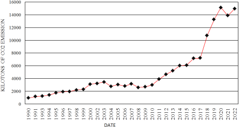
6. Trend of Human Causes on Climate Change
6.1. Burning Fossil Fuels
The anthropogenic drivers of climate change in Nepal have manifested with alarming intensity, exacerbating environmental degradation and accelerating glacial retreat in the Himalayan region. Foremost among these drivers is the combustion of fossil fuels, which releases copious amounts of carbon dioxide (CO
2) into the atmosphere, perpetuating the greenhouse effect and elevating global temperatures (
Figure 2). Nepal, though not a major industrial emitter, faces transboundary pollution from neighboring industrial giants, compounding local climatic stressors. Deforestation further amplifies this crisis, as forests—critical carbon sinks—are decimated at an annual rate of 1.7%, surpassing both Asian (1%) and global (1.3%) averages
| [8] | Dhital, Narayan. (2009). Reducing emission from deforestation and forest degradation: exploring the possibilities. Journal of forest and livelihood. 8. 56-62. |
[8]
. The loss of 48,589 hectares of forest cover annually not only diminishes CO
2 sequestration but also exacerbates soil erosion and alters regional hydrological cycles, intensifying vulnerabilities to landslides and floods.
The proliferation of wildfires has emerged as another pernicious contributor, with incidents escalating from 900 in 2001 to 5,500 by 2016
| [12] | Parajuli, Ashok & Chand, Deepak & Rayamajhi, Bishal & Khanal, Rajendra & Baral, Sony & Malla, Yam & Paudel, Shambhu. (2015). Spatial and temporal distribution of forest fires in Nepal. |
[12]
. These conflagrations, fueled by prolonged droughts and anthropogenic ignition, ravage native vegetation, releasing stored carbon and particulate matter into the atmosphere. Satellite imagery from NASA underscores the spatial and temporal ubiquity of these fires, which correlate with accelerated snowmelt and glacial lake formation in high-altitude regions. The incineration of biomass not only exacerbates atmospheric warming but also disrupts microclimates, further destabilizing fragile alpine ecosystems.
Industrial activities, though limited in scale, discharge substantial greenhouse gases (GHGs), including methane (CH
4) and nitrous oxide (N
2O), which possess global warming potentials far exceeding CO
2 | [13] | Kumar, Dr. Manoj & Patra, Ashok & Swarup, Anand. (2011). Impact of Climate Change on Fertilizer Demand in Agriculture: Concerns and Imperatives for Food Security in India. Indian Journal of Fertilisers. 7. 48-62. |
[13]
. Unregulated emissions from cement production and fossil fuel combustion have surged, as evidenced by longitudinal data depicting a steep upward trajectory in Nepal’s annual carbon emissions. The absence of stringent regulatory frameworks perpetuates this trend, undermining efforts to mitigate climate impacts. Agriculture, the backbone of Nepal’s economy, paradoxically fuels climate change through unsustainable practices. The rampant use of nitrogen-based fertilizers—30 times more potent than CO
2—has surged, driven by the demand for higher crop yields
| [14] | He, Zijian & Bangxin, Ding & Pei, Shuyao & Cao, Hongxia & Liang, Jiaping & Li, Zhijun. (2023). The impact of organic fertilizer replacement on greenhouse gas emissions and its influencing factors. Science of The Total Environment. 905. 166917. https://doi.org/10.1016/j.scitotenv.2023.166917 |
[14]
. Livestock farming further compounds the issue, as enteric fermentation in ruminants releases methane, a GHG 25 times more effective at trapping heat than CO
2. Data reveal a stark increase in chemical fertilizer usage, which not only elevates emissions but also degrades soil health, creating a vicious cycle of dependency and environmental harm
| [13] | Kumar, Dr. Manoj & Patra, Ashok & Swarup, Anand. (2011). Impact of Climate Change on Fertilizer Demand in Agriculture: Concerns and Imperatives for Food Security in India. Indian Journal of Fertilisers. 7. 48-62. |
[13]
. These anthropogenic activities collectively precipitate a feedback loop of climatic disruption. The resultant rise in temperatures—0.06°C annually since 1975—has catalyzed glacial melt, spawning over 700 new glacial lakes between 2005 and 2024. This phenomenon, documented via satellite imagery, underscores the inexorable link between human actions and ecological upheaval. Without immediate intervention, the confluence of deforestation, industrial emissions, and agricultural malpractice will perpetuate Nepal’s status as the fourth most climate-vulnerable ratio, with dire implications for water security, biodiversity, and socioeconomic stability.
Figure 2. Deforestation rate vs. time.
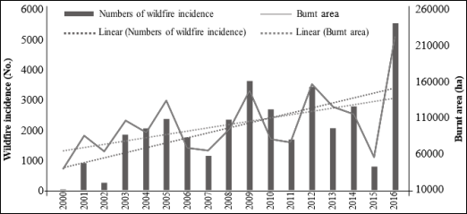
6.2. Trend of Wildfire in Nepal
The escalating trend of wildfires in Nepal has emerged as a significant anthropogenic driver of climate change, exacerbating environmental degradation and altering regional climatic patterns. According to
| [12] | Parajuli, Ashok & Chand, Deepak & Rayamajhi, Bishal & Khanal, Rajendra & Baral, Sony & Malla, Yam & Paudel, Shambhu. (2015). Spatial and temporal distribution of forest fires in Nepal. |
[12]
, Nepal has witnessed a marked increase in wildfire incidents during the dry season (November to June), with recorded fires surging from 900 in 2001 to nearly 5,500 by 2016. This exponential rise underscores a dire correlation between deforestation, carbon emissions, and rising atmospheric temperatures. Wildfires not only decimate vast tracts of forest—Nepal loses approximately 48,589 hectares annually, a rate of 1.7% surpassing both Asian and global averages
| [8] | Dhital, Narayan. (2009). Reducing emission from deforestation and forest degradation: exploring the possibilities. Journal of forest and livelihood. 8. 56-62. |
[8]
—but also release copious amounts of stored carbon dioxide, further amplifying the greenhouse effect. The combustion of organic matter during these fires emits potent greenhouse gases, including CO
2 and methane, which contribute to the accelerated warming of the Himalayan region, where temperatures are already rising at 0.06°C annually
.
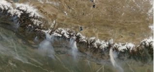
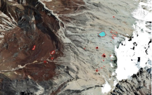
The ramifications of wildfires extend beyond immediate ecological destruction, profoundly influencing glacial dynamics and hydrological systems. Satellite imagery from NASA (
Figure 3) reveals extensive wildfire-induced deforestation, which reduces the albedo effect and increases solar absorption, thereby elevating local temperatures. This thermal anomaly accelerates glacier retreat, as evidenced by the formation of 705 new glacial lakes between 2005 and 2024
| [16] | Hu J, Yao X, Duan H, Zhang Y, Wang Y et al (2022) Temporal and spatial changes and GLOF susceptibility assessment of glacial lakes in Nepal from 2000 to 2020. Remote Sens 14: 5034. https://doi.org/10.3390/rs14195034 |
[16]
. The loss of forest cover diminishes the land's capacity to sequester carbon, creating a pernicious feedback loop: higher temperatures foster more frequent and intense wildfires, which in turn exacerbate climate change. Furthermore, the deposition of soot and ash on glaciers—a phenomenon documented in MODIS images (
Figure 4)—reduces surface reflectivity, hastening melt rates and destabilizing glacial lakes. Such lakes, now numbering 2,631 in Nepal’s Himalayas, pose a latent threat of glacial lake outburst floods (GLOFs), which have already caused transboundary devastation.
The synergistic interplay between wildfires and climate change underscores an urgent need for mitigation strategies. The incineration of Nepal’s forests not only depletes biodiversity but also disrupts precipitation patterns, as evapotranspiration from verdant landscapes is critical for monsoon dynamics. Studies indicate that erratic rainfall—peaking at 386 mm in Solukhumbu (2024)—and heightened humidity fluctuations (a spike to 680 in Langtang, 2015) are direct consequences of these disturbances (
Figures 6–8). The resultant hydrological volatility exacerbates soil erosion, landslides, and floods, compounding the vulnerability of agrarian communities. In summation, wildfires in Nepal epitomize a quintessential environmental quandary: they are both a catalyst and a consequence of climate change, necessitating immediate intervention through reforestation, sustainable land management, and stringent emission controls to curtail their deleterious impact on the region’s fragile ecosystems.
Figure 3. Wildfire satellite image of Nepal (Source: NASA).
Figure 4. Month wise wildfire incidence and burnt area (Source: MODIS images, 2000 to 2016).
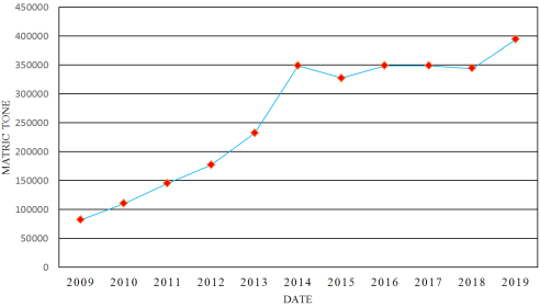
6.3. Contribution of Industrial Sector
The industrial sector constitutes a significant anthropogenic contributor to climate change, exacerbating atmospheric greenhouse gas concentrations through relentless emissions of carbon dioxide (CO
2) and other deleterious gases. In Nepal, the proliferation of industrial activities has precipitated a marked escalation in carbon emissions, directly correlating with the accelerated warming trends observed in the Himalayan region (
Figure 5). This phenomenon is particularly pernicious given the region's heightened vulnerability to climatic perturbations, as evidenced by the rapid glacial retreat and proliferation of glacial lakes documented in this study.
Empirical data from this research underscore a disconcerting trajectory in Nepal's industrial carbon emissions. The combustion of fossil fuels for energy generation and cement production has been identified as a principal culprit, with emissions exhibiting a near-exponential rise over the past two decades. For instance, the annual carbon emission rate in Nepal has surged dramatically, mirroring global trends but with localized ramifications that are disproportionately severe. The absence of stringent regulatory frameworks exacerbates this issue, permitting industries to operate with minimal adherence to emission mitigation protocols. Consequently, the atmospheric concentration of CO2 has reached unprecedented levels, intensifying the greenhouse effect and perpetuating a feedback loop of rising temperatures and glacial melt.
Furthermore, the industrial sector's reliance on archaic technologies and non-renewable energy sources perpetuates inefficiencies and amplifies its carbon footprint. The unchecked discharge of industrial effluents and particulate matter not only degrades air quality but also accelerates the albedo reduction of Himalayan snow cover, hastening melt rates. This is corroborated by satellite imagery analysis, which reveals a stark northward migration of snowlines and a concomitant increase in glacial lake formation—a direct consequence of industrial-induced warming. The data presented in this study illustrate that regions proximate to industrial hubs exhibit higher temperature anomalies, further validating the sector's culpability in regional climate disruption.
The transboundary implications of industrial emissions are equally alarming. Pollutants emanating from Nepal's industrial corridors often traverse geopolitical boundaries, compounding the climatic stressors faced by neighboring regions. This insidious cross-border contamination underscores the imperative for multilateral cooperation in emission regulation
| [2] | Immerzeel, W. W., Van Beek, L. P., Bierkens, M. F., 2010. Climate changewill affect the Asian water towers. Science 328 (5984), 1382–1385. |
[2]
. Moreover, the industrial sector's profligate energy consumption exacerbates deforestation, as forests are razed to accommodate infrastructure and fuelwood demand, thereby diminishing carbon sequestration capacity
| [8] | Dhital, Narayan. (2009). Reducing emission from deforestation and forest degradation: exploring the possibilities. Journal of forest and livelihood. 8. 56-62. |
[8]
.
The industrial sector's contribution to climate change in Nepal is both profound and multifaceted, characterized by rampant emissions, technological stagnation, and ecological degradation. The empirical evidence marshaled in this research unequivocally links industrial activities to the escalating climate crisis in the Himalayas, necessitating immediate policy interventions to curtail emissions, incentivize renewable energy adoption, and foster sustainable industrial practices. Failure to address these exigencies will invariably precipitate cataclysmic environmental repercussions, further imperiling the fragile ecosystems and communities reliant on them.
Figure 5. Annual rate of carbon emissions in Nepal.
6.4. Contribution of Agriculture
The agricultural sector in Nepal significantly exacerbates climate change through the emission of potent greenhouse gases (GHGs), which are byproducts of modern farming practices. Methane (CH
4), a GHG with a global warming potential 25 times greater than carbon dioxide (CO
2) over a 100-year period, is predominantly released during livestock enteric fermentation and rice cultivation
| [14] | He, Zijian & Bangxin, Ding & Pei, Shuyao & Cao, Hongxia & Liang, Jiaping & Li, Zhijun. (2023). The impact of organic fertilizer replacement on greenhouse gas emissions and its influencing factors. Science of The Total Environment. 905. 166917. https://doi.org/10.1016/j.scitotenv.2023.166917 |
[14]
. Concurrently, the excessive application of nitrogen-based fertilizers in crop production generates nitrous oxide (N
2O), a gas 300 times more effective at trapping heat than CO
2 | [13] | Kumar, Dr. Manoj & Patra, Ashok & Swarup, Anand. (2011). Impact of Climate Change on Fertilizer Demand in Agriculture: Concerns and Imperatives for Food Security in India. Indian Journal of Fertilisers. 7. 48-62. |
[13]
. These emissions are particularly alarming in Nepal, where agricultural reliance is pervasive, and the use of synthetic fertilizers has escalated precipitously over recent decades (
Figure 6).
Empirical data underscore this trend: the unbridled adoption of chemical fertilizers has surged annually, directly correlating with heightened atmospheric GHG concentrations
| [13] | Kumar, Dr. Manoj & Patra, Ashok & Swarup, Anand. (2011). Impact of Climate Change on Fertilizer Demand in Agriculture: Concerns and Imperatives for Food Security in India. Indian Journal of Fertilisers. 7. 48-62. |
[13]
. This phenomenon is exacerbated by the shift from traditional organic farming to intensive, input-dependent agriculture, which not only degrades soil health but also amplifies carbon emissions
| [14] | He, Zijian & Bangxin, Ding & Pei, Shuyao & Cao, Hongxia & Liang, Jiaping & Li, Zhijun. (2023). The impact of organic fertilizer replacement on greenhouse gas emissions and its influencing factors. Science of The Total Environment. 905. 166917. https://doi.org/10.1016/j.scitotenv.2023.166917 |
[14]
. Furthermore, deforestation for agricultural expansion compounds the issue, as it diminishes carbon sequestration capacity. Between 1990 and 2020, Nepal’s deforestation rate averaged 1.7% per year—exceeding both Asian (1%) and global (1.3%) averages—thereby releasing stored carbon and reducing the land’s ability to mitigate climate effects
| [8] | Dhital, Narayan. (2009). Reducing emission from deforestation and forest degradation: exploring the possibilities. Journal of forest and livelihood. 8. 56-62. |
[8]
.
The ramifications of these practices are profound. Elevated GHG emissions from agriculture contribute to the accelerated warming of the Nepal Himalayas, where temperatures are rising at 0.06°C annually—a rate surpassing global averages. This thermal increase hastens glacier melt and glacial lake formation, with 705 new lakes emerging between 2005 and 2024. Such environmental perturbations disrupt hydrological cycles, intensify monsoon variability, and exacerbate the frequency of catastrophic events like glacial lake outburst floods (GLOFs).
To mitigate these deleterious impacts, a paradigm shift toward sustainable agriculture is imperative. Promoting organic farming, reducing fertilizer overuse, and implementing agroforestry could attenuate GHG emissions while enhancing resilience. Policymakers must prioritize these measures to curb agriculture’s contribution to climate change and safeguard Nepal’s fragile ecosystems.
Figure 6. Years wise contribution of agricultural sectors.
7. Important Parameters and Their Past and Present Status
The signs of climate change in the Himalayas are evident in several ways. There has been a rise in temperatures and glacial melt, along with changes in precipitation patterns and increasing fall rain intensity. Humidity levels are also fluctuating, and there are noticeable changes in vegetation based on seasonal shifts. Furthermore, diseases commonly found in the Terai region, such as malaria and dengue, are increasingly being observed in the Himalayan districts. These factors collectively indicate the gradual impact of climate change in the Himalayas. The all the
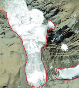
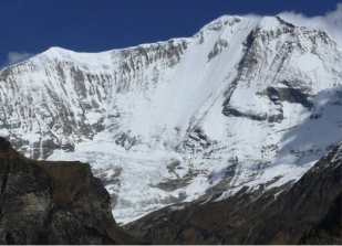
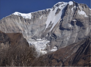
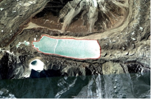
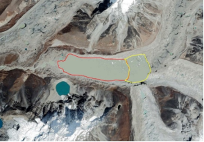
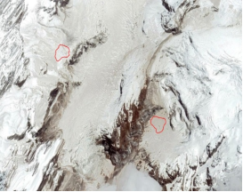
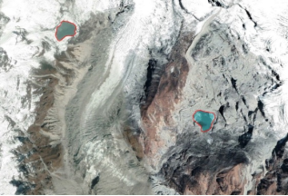
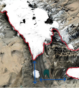
Figures 7 below a, b, c, d, e, f, g, h, I, and j represents the changes in the snow caps and melting process and the glacial lake formation in different parts of the Himalayan ranges. Which is the direct impacts of climate change in the Nepal Himalaya. Due to this impacts there has been seen a serious problem of occurring Glacial Lake Outburst Flood (GLOF) that are responsible for landslides and floods in vulnerable area.
a. 2005 Langtang Area b. 2020 Langtang Area
c. 2008 Shipal himal in Far western Nepal d. 2020 Shipal himal in Far western Nepal
e. Mt Everest Area, 2009 f. Mt Everest Area, 2014
g. Annapurna Area, 2012 h. Annapurna Area, 2016
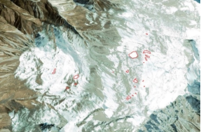
Figure 7. Records of Glacier melt and slow lake formation.
The Nepal Himalaya has exhibited palpable shifts in critical climatic and environmental parameters over the past two decades, underscoring the profound impacts of climate change. These changes are manifest in rising temperatures, altered precipitation patterns, glacial retreat, and the proliferation of glacial lakes, each exacerbating the region's vulnerability to natural disasters.
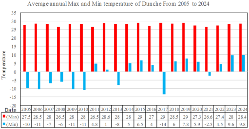
7.1. Temperature Variability
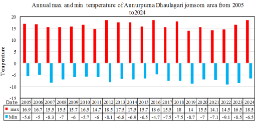
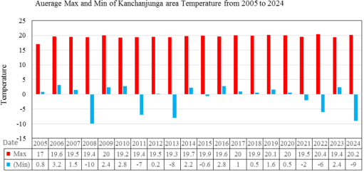
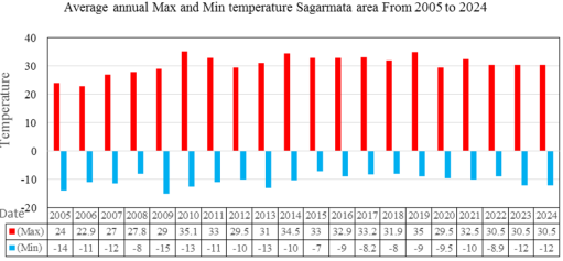
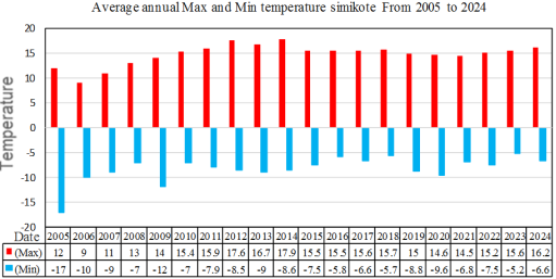
The study reveals a discernible upward trend in temperatures across the Himalayan region. Data from 2005 to 2024 (
Figure 8) indicate that the average annual temperature in snow-capped regions fluctuated between -10°C and 30°C, with anomalies increasingly deviating from historical norms. The mean annual temperature rise of 0.06°C/year surpasses global averages, culminating in accelerated glacier melt. The elevation-dependent warming effect, with lapse rates of 0.5 to 0.7°C per 100 meters, further precipitates the disintegration of glacial systems.
7.2. Precipitation and Rainfall Extremes
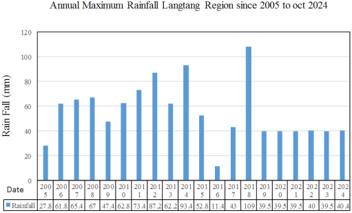
Rainfall patterns have become increasingly erratic, with marked variability across regions. For instance, the Langtang region recorded a maximum annual rainfall of 109 mm in 2018, dwarfing the minimum of 46 mm in 2016. Similarly, the Solukhumbu region experienced a surge to 386 mm in 2024, a stark contrast to 95.5 mm in 2021. Such volatility predisposes the region to landslides and floods, compounding risks for downstream communities. The Kanchenjunga-Taplejung area recorded an extreme of 137 mm in 2016, highlighting the precariousness of monsoon intensification.
7.3. Glacial Lake Dynamics
Photo 3 Records of Glacier melt and slow lake formation
The exponential growth of glacial lakes epitomizes the pernicious effects of rising temperatures. Satellite imagery analysis evidences a dramatic increase from 1,926 lakes in 2005 to 2,631 in 2024—a net gain of 705 lakes Specific regions, such as Sagarmatha and Langtang, saw lake counts escalate from 462 to 715 and 430 to 630, respectively. This proliferation is attributable to glacial retreat rates of 40% in area and 50% in volume per 1°C temperature rise, underscoring the inexorable link between warming and hydrogeomorphic hazards.
7.4. Humidity and Secondary Impacts
Humidity trends oscillated capriciously, with Langtang registering an anomalous peak of 680 in 2015. Such fluctuations correlate with shifting disease vectors, as malaria and dengue, once endemic to the Terai, now infest Himalayan districts. Agricultural systems also face disruption, with crop phenology accelerating due to aberrant seasonal shifts.
7.5. Snowline Retreat
Comparative imagery reveals a conspicuous northward migration of snowlines, signifying reduced snow cover and barren high-altitude landscapes. This phenomenon exacerbates water scarcity and jeopardizes the region’s hydrological stability. The convergence of these parameters portends a dire future for the Nepal Himalaya, necessitating urgent mitigation and adaptation strategies to avert catastrophic outcomes. The empirical data corroborate the inextricable role of anthropogenic climate change in precipitating these transformations.
7.6. Changes in Rainfall
The profound and disconcerting transformation in precipitation patterns across the Nepal Himalaya, underscoring the pervasive influence of climate change. The analysis of 20 years of rainfall data from disparate regions reveals not only erratic fluctuations but also an alarming intensification of monsoonal activity, which portends dire consequences for the region's geomorphological stability and hydrological systems.
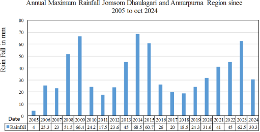
In the Jomsom-Dhaulagiri-Annapurna region, the data evinces a capricious oscillation in annual rainfall, with years such as 2008, 2009, 2014, 2015, and 2023 recording precipitous averages exceeding 50 mm—markedly higher than the normative threshold. Conversely, the years 2004, 2011, 2012, 2017, and 2018 were characterized by a paucity of precipitation, with averages plummeting below 20 mm (
Figure 9). This erratic variability epitomizes the destabilizing effects of climatic perturbations, which exacerbate the susceptibility of the terrain to landslides and catastrophic flooding.
The Langtang region, however, manifests a more unequivocal trend toward heightened precipitation. The apogee of this trend was reached in 2018, when rainfall surged to an unprecedented 109 mm—a figure that eclipses the regional average and underscores the escalating volatility of weather systems. Even the nadir of 46 mm, recorded in 2016, remains anomalously high, with most years consistently registering above 50 mm. Such unrelenting deluges not only imperil the fragile Himalayan ecosystems but also presage an exacerbation of geohazards, including slope failures and riverine inundations.
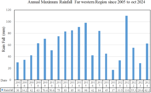
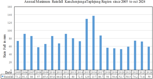
Similarly, the Kanchenjunga-Taplejung region exhibits an inexorable rise in rainfall intensity, with 2016 witnessing a staggering 137 mm—a magnitude fraught with peril for the region's steep and unstable topography. Even the ostensibly subdued minimum of 52.7 mm in 2020 surpasses benign thresholds, rendering the area perennially vulnerable to hydro-meteorological disasters. The Far Western region, though initially demonstrating a gradual ascent in precipitation from 30 mm in 2005 to 98 mm in 2015, subsequently experienced a tumultuous deviation, with 2021 recording 110 mm and 2019 plunging to a mere 17 mm. This erraticism epitomizes the capriciousness of contemporary climatic regimes.
Most egregious, however, is the Solukhumbu region, where rainfall has attained a magnitude unparalleled elsewhere in the Himalaya. The apotheosis of this trend materialized in 2024, with an extraordinary 386 mm of rainfall, while the minimum of 95.5 mm in 2021 still dwarfs comparative figures from other regions. The pervasiveness of such excessive precipitation not only underscores the region's acute vulnerability to climate-induced hazards but also heralds a future wherein the frequency and severity of disasters may escalate inexorably.
7.7. Changes in Temperature and Humidity
The temperature data shows that maximum temperature recorded in between 2005 to 2024 were recorded 20-30 degree Celsius and minimum temperature were around -10 degree Celsius (
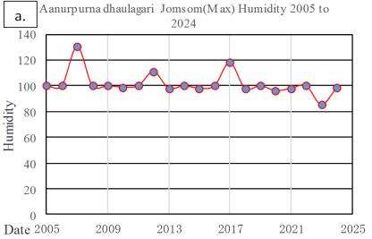
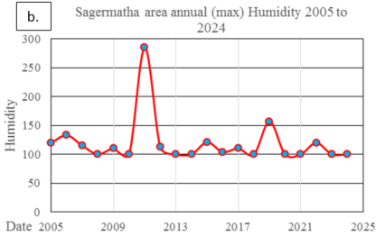
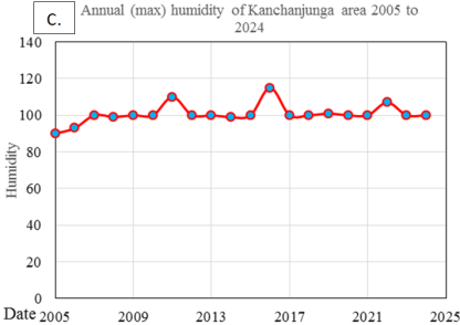
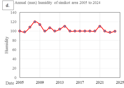
Figure 10). These ranges of temperature is significantly higher than normal in Himalayan region which have been playing major role in glacier melting and formation of the lakes in Himalayan region. For Annapurna Dhaulagiri Jomsom, humidity were increasing and decreasing pattern. The maximum value of humidity was 120 and minimum was nearly 80. Similarly, for maximum humidity measured were almost 300 and average line were 100. For Kanchenjunga and Simikot area there cannot be seen and drastic change in humidity following the average line at 100. However, for Langtang area in 2015, there the humidity were change significantly large up to a value 680.
Figure 8. Trends of temperature variation in five different snow cap regions.
Figure 9. Trends of temperature variation in five different snow cap regions.
Figure 10. showing trend of annuals humidity of five different regions.
8. Glacier Melting and Rapid Formation of Glacial Lakes
The global warming has impacted the Nepal Himalaya directly in significantly higher rate in comparison to other parts of the worlds. The major issues causing global warming are burning fossils fuels, deforestation, unhealthy practice of agriculture, industrialization, urbanization and others. These activities are mainly responsible to generate large volume of carbon dioxide (CO2), methane (CH4), nitrous oxide (N2O) in the atmosphere that cause rise in temperature of the atmosphere. These several activities has exposed great impact on global climate such as temperature changes, change in precipitation, glacier melting, loss of biodiversity and ecosystem. In a country like Nepal, Geographically complex topography, the climate change has adversely impacted in comparison to other countries.
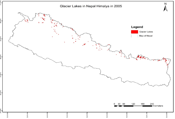
Figure 11. Number of glacial lake in 2005.
Nepal Himalaya ranges have been experiencing the rapid glacier meting and formation of glacial lakes.
Figure 11, figure,
Figure 13,
Figure 14 and
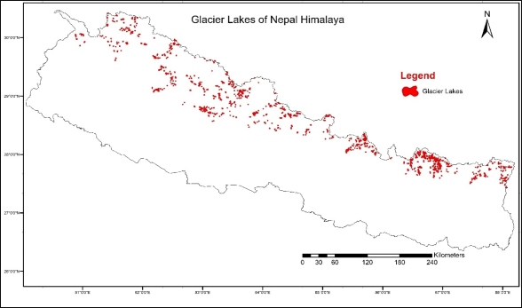
Figure 15 clearly indicates the rapid formation of glacial lakes due to rise in temperature of surrounding. In 2005, there were 117, 462, 430, 303, 344, and 211 glacial lakes recorded in Kanchenjunga, Sagarmatha, Langtang, Dhaulagiri-Annapurna, Shey Phoksundo, and Mugu-Shypal Himal area respectively. But there can be seen dramatic rise in number in 2024, the numbers of lakes were recorded to be 220,715, 630,372,418, and 276 in in Kanchenjunga, Sagarmatha, Langtang, Dhaulagiri-Annapurna, Shey Phoksundo, and Mugu-Shypal Himal area respectively. This data reveals that over 700 new glacial lakes were formed in Nepal Himalaya within the interval of 20 years. This is dramatic rise in numbers of glacial lakes in Nepal Himalaya. Therefore, careful consistent monitoring of glacial lakes and glacier melting is essential for advance research and to mitigate the disasters related to glacial lakes and glacier like snow avalanches, and GLOFs.
Figure 12. Number of glacial lakes in different Nepal Himalayan ranges in 2024.
Figure 13. Numbers of glacial lakes in different ranges of Nepal Himalaya in 2005.
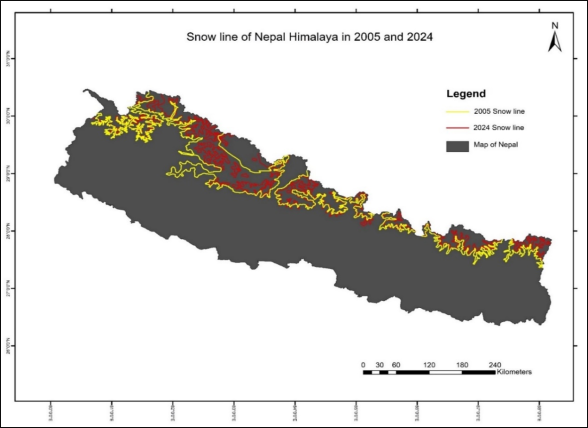
Figure 14. Showing significant shifting of snowline boundary towards north due to climate changes impacts.
Figure 15. Number of Glacial Lakes in different range of Nepal Himalaya in 2024.
9. Discussion
The impacts climate change of change in glacier of Nepal Himalaya have been observing each year, rapid glacier melting and formation of glacial lakes. This process of glacier melting is directly linked to rise in global temperature in each year. The studies have shown that mean annual rise in temperature of Nepal Himalayan region is 0.06˚c/year, and climate of Nepal Himalaya is changing at faster rate than global rate
. Nepal is ranked the fourth most vulnerable country to climate change. The rapid glacier melting is one of the primary impacts of climate change. The rapid formation of glacier lakes started after 1950s in response to glacier retreat due to climate change
. Many studies has presented the comprehensive mapping on glacier lakes and its changes at national level
| [16] | Hu J, Yao X, Duan H, Zhang Y, Wang Y et al (2022) Temporal and spatial changes and GLOF susceptibility assessment of glacial lakes in Nepal from 2000 to 2020. Remote Sens 14: 5034. https://doi.org/10.3390/rs14195034 |
| [17] | Khadka N, Zhang G, Thakuri S (2018) Glacial lakes in the Nepal Himalaya: inventory and decadal dynamics (1977–2017). Remote Sens 10: 1913.
https://doi.org/10.3390/rs10121913 |
[16, 17]
. The most recent study showed 2420 glacial lakes (> 0.0001 km
2, ~ 87.21 km
2) in 2020 using high-resolution Gaofen-1/6 and Sentinel-2 data (Hu et al. 2022). A national scale inventory reported that the areas of the glaciers including both clean and debris-covered in the Koshi, Gan daki, Karnali, and Mahakali river basins in Nepal were 1102, 1664, 1022, and 112 km2, respectively, in 2010
| [20] | Bajracharya SR, Maharjan SB, Shrestha F, Bajracharya OR, Baidya S (2014) Glacier status in Nepal and decadal change from 1980 to 2010 based on Landsat data. International Centre for Integrated Mountain Development.
https://lib.icimod.org/record/29591 Last accessed 2023-10-05 |
[20]
.
Our studies also revealed that total number of glacier lakes in the different ranges of Himalaya has been changed since 2005 to 2024. As shown in
Figures 9, 10, 11 and 12, the formation of glacial lakes in Nepal Himalaya is in dramatic rate. In the Kanchenjunga area numbers of lakes in 2005 were 176 but in 2024 it increases to 220. In the similar way, the numbers of glacial lakes in Sagarmatha area increases from 462 to 715. While for Langtang area, numbers of glacial lakes increases from 430 to 630 and for Dhaulagiri and Annapurna Area it increases from 303 to 372. In 2005, the number of lakes in Shey Phoksundo and Mugu-Shyphal Himal were recorded 344 and 211, but the number climbed up to 418 and 276 respectively in 2024. In total, numbers of glacial lakes recorded were1926 in 2005 and 2631 in 2024. This dramatic changes in numbers of glacial lakes in overall Nepal Himalaya suggested that 705 new glacial lakes were formed in two decades.
Between 2005 and 2024, there has been a noticeable increase in the number of glacial lakes in Nepal Himalaya, with over 700 new lakes forming this period. This rise is mainly due to the rapid melting of glacier by dramatic rise in temperatures. Several studies revealed that the increasing trends in annual maximum, mean, and minimum temperature (0.02 to 0.16 °C yr−1) over Nepal are higher than global increase on landmass. Many studies revealed the elevation dependency of temperature and varied rates of lapse rate (0.5 to 0.7 °C/100 m). This is clear indicator to climate changes which could impact directly as well as indirectly in many components of nature. Our studies suggests the important of long-term monitoring of the climatological condition of Himalayan region for more accurate and precision on further studies and monitoring of climate changes in Nepal Himalaya. There are still limited climatological stations in higher elevation area. These stations should be established in the all the required locations with routine maintenance. These could be the important tools for advanced means of data collection for further research and monitoring. The continuous monitoring of glacier lakes is also essential part for the disaster risks reduction. There are many glacial lakes in unstable area which have the higher potential of GLOFs. Consistent monitoring of glaciers and glacial lakes plays a key role in enhancing hazard and risk evaluation. Considering the critical significance of mountain regions, greater attention and effort are required to understand the nature and impact of climate change in these environmentally sensitive areas.
10. Conclusion
Overall, temperatures are rising in the Nepal Himalayas. Monsoonal activity has also intensified, and the process of glacier melting and lake formation is gradually increasing. These growing lakes pose significant risks, as the volume of solid water in the Nepal Himalayas is decreasing due to glacial melt. This presents major challenges and problems in the near future. Areas that were once covered by snow are now turning into barren wastelands. Analysis of satellite imagery shows that snow lines are shifting northward compared to the past. This clearly indicates that the Nepal Himalayas are affected by climate change, and its direct impacts are becoming increasingly visible. Over the past 20 years, analyzing temperature, humidity, precipitation, disease patterns, and agricultural trends reveals that climate change is intensifying in the Nepal Himalayas. The temperatures have gradually increased, and monsoonal activity has become more pronounced. Diseases commonly found in the Terai, such as malaria and dengue, are now frequently appearing in Himalayan districts. Additionally, there has been a noticeable acceleration in the blooming and fruiting processes of crops, indicating shifts in seasonal patterns. Comprehensive studies show that our Himalayas are under the influence of climate change, with rising glacial melt and increasing glacier lake formation. As melting continues, the volume of solid water is decreasing, leading to greater risks of glacial lake outburst floods and landslides. These trends highlight the urgent challenges posed by climate change in the region. The climate change occurring in our region poses significant challenges to the tourism sector, the state’s economy, food security, and health security etc. This necessitates the development of specific adaptation strategies. The impact of climate change has been substantial on our country’s economy and infrastructure, resulting in considerable loss of life and property, as well as severe damage to physical structures. Addressing these issues is crucial for safeguarding our communities and sustaining economic growth.
Abbreviations
CO2 | Carbon Dioxide |
CH4 | Methane |
DHM | Department of Hydrology and Meteorology (Government of Nepal) |
ERA5 | ECMWF Reanalysis v5 (A global climate reanalysis dataset) |
GRACE | Gravity Recovery and Climate Experiment |
GHG | Greenhouse Gas |
GIS | Geographic Information System |
GLOF | Glacial Lake Outburst Flood |
ICIMOD | International Centre for Integrated Mountain Development |
IPCC | Intergovernmental Panel on Climate Change |
MODIS | Moderate Resolution Imaging Spectroradiometer |
NASA | National Aeronautics and Space Administration |
N2O | Nitrous Oxide |
NDSI | Normalized Difference Snow Index |
NDWI | Normalized Difference Water Index |
Conflicts of Interest
The authors declare that there are no conflicts of interest regarding the publication of this paper.
References
| [1] |
Singh, P., Haritashya, U. K., Kumar, N., Singh, Y., 2006. Hydrological characTearistics of the Gangotri Glacier, central Himalayas, India. J. Hydrol. 327 (3–4), 55–67.
|
| [2] |
Immerzeel, W. W., Van Beek, L. P., Bierkens, M. F., 2010. Climate changewill affect the Asian water towers. Science 328 (5984), 1382–1385.
|
| [3] |
Dhimal, M., O’Hara, R. B., Karki, R., Thakur, G. D., Kuch, U., & Ahrens, B. (2014). Spatio–temporal distribution of Malaria and its association with climatic factors andvector–control interventions in two high–risk districts of Nepal. Malaria Journal, 13(1), 457.
https://doi.org/10.1186/1475-2875-13-457
|
| [4] |
Gansser, A., 1964. In: Geology of the Himalayas. Wiley Interscience, London. 289 p.
|
| [5] |
Hagen, T., 1969. Report on the geological Survey of Nepal. Preliminary reconnaissance: Denkschriften der Schweizerischen Naturforchenden Gesellschaft, Memoires de la Societte Helvetique des Sciences naturees, Zurich, v. 86, pp. 185
|
| [6] |
Raut, A. K. (2004). Climate change: Nepalese perspective. Earthtimes Maplecroft (2010). “Big economies of the future - Bangladesh, India, Philippines, Vietnam and Pakistan - m o st at risk from climate change.” Bath, U. K., Oct. 21, 2010
|
| [7] |
Karki, Rahul & Gurung, Dr. Anup. (2012). An Overview of Climate Change And Its Impact on Agriculture: a Review From Least Developing Country, Nepal. Int. J. Ecosys. 2. 19-24.
https://doi.org/10.5923/j.ije.20120202.03
|
| [8] |
Dhital, Narayan. (2009). Reducing emission from deforestation and forest degradation: exploring the possibilities. Journal of forest and livelihood. 8. 56-62.
|
| [9] |
Mool, P. & Bajracharya, Samjwal & S. P. Sakya, K. & Baidya, A.. (2002). Inventory of glaciers, glacial lakes and glacial lake outburst floods monitoring and early warning systems in theHindu-KushHimalayan region, Nepal.. International Center for Integrated Mountain Development (ICIMOD) tech.
|
| [10] |
lves, J. D., Shrestha, R. B. and Mool, P. K. (2010) Formation of Glacial Lakes in the Hindu Kush-Himalayas and GLOF Risk Assessment. International Centre for Integrated Mountain Development, Kathmandu.56pp.
|
| [11] |
Glacial Lakes and Glacial Lake Outburst Floods in Nepal. Kathmandu: ICIMOD.
http://www.icimod.org/publications
|
| [12] |
Parajuli, Ashok & Chand, Deepak & Rayamajhi, Bishal & Khanal, Rajendra & Baral, Sony & Malla, Yam & Paudel, Shambhu. (2015). Spatial and temporal distribution of forest fires in Nepal.
|
| [13] |
Kumar, Dr. Manoj & Patra, Ashok & Swarup, Anand. (2011). Impact of Climate Change on Fertilizer Demand in Agriculture: Concerns and Imperatives for Food Security in India. Indian Journal of Fertilisers. 7. 48-62.
|
| [14] |
He, Zijian & Bangxin, Ding & Pei, Shuyao & Cao, Hongxia & Liang, Jiaping & Li, Zhijun. (2023). The impact of organic fertilizer replacement on greenhouse gas emissions and its influencing factors. Science of The Total Environment. 905. 166917.
https://doi.org/10.1016/j.scitotenv.2023.166917
|
| [15] |
Shrestha, R. L., & Shrestha, S. (2015). "Climatic Zones of Nepal." Nepal Journal of Environmental Science
|
| [16] |
Hu J, Yao X, Duan H, Zhang Y, Wang Y et al (2022) Temporal and spatial changes and GLOF susceptibility assessment of glacial lakes in Nepal from 2000 to 2020. Remote Sens 14: 5034.
https://doi.org/10.3390/rs14195034
|
| [17] |
Khadka N, Zhang G, Thakuri S (2018) Glacial lakes in the Nepal Himalaya: inventory and decadal dynamics (1977–2017). Remote Sens 10: 1913.
https://doi.org/10.3390/rs10121913
|
| [18] |
Bajracharya SR, Mool P (2009) Glaciers, glacial lakes and glacial lake outburst floods in the Mount Everest region Nepal. Ann Glaciol 50: 81–86.
https://doi.org/10.3189/172756410790595895
|
| [19] |
Upadhayaya RP, Baral MP (2020) Trends of climate change in some selected districts of Western Nepal. Janapriya J Interdiscip Stud 9: 148–158.
http://catalog.nnl.gov.np/bitstream/123456789/839/1/JJIS_Vol%20IX.pdf#page=154
Assessed 2023-10-05
|
| [20] |
Bajracharya SR, Maharjan SB, Shrestha F, Bajracharya OR, Baidya S (2014) Glacier status in Nepal and decadal change from 1980 to 2010 based on Landsat data. International Centre for Integrated Mountain Development.
https://lib.icimod.org/record/29591
Last accessed 2023-10-05
|
| [21] |
Acharya, M.; Timalsina, A.; Paudel, U. Shear Strength Reduction Analysis of Slope by Numerical Modelling Based on Finite Element Method. Am. J. Sci. Eng. Technol. 2023, 8, 125–132.
|
| [22] |
Bhandari, K., Acharya, M., Dhital, M. R., & Shrestha, S. (2023). Landslide Susceptibility Mapping of West Central Nepal Lesser Himalaya Baglung Municipality, Baglung, Nepal. American Journal of Applied Scientific Research.
https://doi.org/10.11648/j.ajasr.20230904.13
|
| [23] |
Bhandari, K., Acahrya, M., Joshi, B., Rokaya, D. K., Dumre, P., et al. (2024). Geotechnical and Geophysical Characterization of the Aklesal Dablyang Landslide: Implications for Slope Stability. Journal of Civil, Construction and Environmental Engineering, 9(6), 211-225.
https://doi.org/10.11648/j.jccee.20240906.14
|
| [24] |
andesh D, Mahendra A, Prakash DU, Chabbilal P, Aasish Giri, Khomendra B (2024) Landslide Hazard Mapping Along the Beni-Lete RoadSection, Myagdi-Mustang Districts, Western Nepal.J Earth Sci Clim Change, 15: 772 Landslide Hazard Mapping Along the Beni-Lete Road Section, Myagdi- Mustang Districts, Western Nepal.
|
Cite This Article
-
APA Style
Bhandari, K., Acharya, M., Belbase, S., Ghmire, A., Shrestha, P., et al. (2025). Impacts of Climate Change on Glacial Lake Formation and GLOF Risks in the Nepal Himalaya (2005-2024):
A Geospatial and Statistical Analysis. Earth Sciences, 14(6), 261-281. https://doi.org/10.11648/j.earth.20251406.15
 Copy
|
Copy
|
 Download
ACS Style
Bhandari, K.; Acharya, M.; Belbase, S.; Ghmire, A.; Shrestha, P., et al. Impacts of Climate Change on Glacial Lake Formation and GLOF Risks in the Nepal Himalaya (2005-2024):
A Geospatial and Statistical Analysis. Earth Sci. 2025, 14(6), 261-281. doi: 10.11648/j.earth.20251406.15
Copy
|
Download
AMA Style
Bhandari K, Acharya M, Belbase S, Ghmire A, Shrestha P, et al. Impacts of Climate Change on Glacial Lake Formation and GLOF Risks in the Nepal Himalaya (2005-2024):
A Geospatial and Statistical Analysis. Earth Sci. 2025;14(6):261-281. doi: 10.11648/j.earth.20251406.15
Copy
|
Download
-
@article{10.11648/j.earth.20251406.15,
  author = {Khomendra Bhandari and Mahendra Acharya and Suraj Belbase and Anil Ghmire and Parbin Shrestha and Sandesh Dhakal},
  title = {Impacts of Climate Change on Glacial Lake Formation and GLOF Risks in the Nepal Himalaya (2005-2024):
A Geospatial and Statistical Analysis},
  journal = {Earth Sciences},
  volume = {14},
  number = {6},
  pages = {261-281},
  doi = {10.11648/j.earth.20251406.15},
  url = {https://doi.org/10.11648/j.earth.20251406.15},
  eprint = {https://article.sciencepublishinggroup.com/pdf/10.11648.j.earth.20251406.15},
  abstract = {This study investigates the impacts of climate change on glacial lake dynamics and associated Glacial Lake Outburst Flood (GLOF) risks in the Nepal Himalaya from 2005 to 2024, employing a comprehensive geospatial and statistical analysis. Utilizing high-resolution satellite imagery and climatological data, we documented a dramatic proliferation of glacial lakes, with the total number increasing from 1,926 to 2,631—a net gain of 705 lakes—across major Himalayan ranges. This rapid formation is directly correlated with significant regional warming, with a mean annual temperature increase of 0.06°C, and erratic precipitation patterns. The research identifies and classifies these expanding lakes, highlighting their growing potential for GLOFs, which pose a severe transboundary threat to downstream communities and infrastructure. Furthermore, the analysis delineates key anthropogenic drivers—including deforestation, escalating wildfires, industrial emissions, and agricultural practices—that are exacerbating the region's climate vulnerability. The findings underscore the critical need for continuous monitoring of glaciers and glacial lakes and the urgent implementation of adaptive mitigation strategies to address the escalating climate-induced hazards in this ecologically fragile and topographically complex region.},
 year = {2025}
}
Copy
|
Download
-
TY  - JOUR
T1  - Impacts of Climate Change on Glacial Lake Formation and GLOF Risks in the Nepal Himalaya (2005-2024):
A Geospatial and Statistical Analysis
AU  - Khomendra Bhandari
AU  - Mahendra Acharya
AU  - Suraj Belbase
AU  - Anil Ghmire
AU  - Parbin Shrestha
AU  - Sandesh Dhakal
Y1  - 2025/12/20
PY  - 2025
N1  - https://doi.org/10.11648/j.earth.20251406.15
DO  - 10.11648/j.earth.20251406.15
T2  - Earth Sciences
JF  - Earth Sciences
JO  - Earth Sciences
SP  - 261
EP  - 281
PB  - Science Publishing Group
SN  - 2328-5982
UR  - https://doi.org/10.11648/j.earth.20251406.15
AB  - This study investigates the impacts of climate change on glacial lake dynamics and associated Glacial Lake Outburst Flood (GLOF) risks in the Nepal Himalaya from 2005 to 2024, employing a comprehensive geospatial and statistical analysis. Utilizing high-resolution satellite imagery and climatological data, we documented a dramatic proliferation of glacial lakes, with the total number increasing from 1,926 to 2,631—a net gain of 705 lakes—across major Himalayan ranges. This rapid formation is directly correlated with significant regional warming, with a mean annual temperature increase of 0.06°C, and erratic precipitation patterns. The research identifies and classifies these expanding lakes, highlighting their growing potential for GLOFs, which pose a severe transboundary threat to downstream communities and infrastructure. Furthermore, the analysis delineates key anthropogenic drivers—including deforestation, escalating wildfires, industrial emissions, and agricultural practices—that are exacerbating the region's climate vulnerability. The findings underscore the critical need for continuous monitoring of glaciers and glacial lakes and the urgent implementation of adaptive mitigation strategies to address the escalating climate-induced hazards in this ecologically fragile and topographically complex region.
VL  - 14
IS  - 6
ER  -
Copy
|
Download